Author Archive

Photo challenge of the week (#7)

March 8, 2010

photo of week 7 Most Madisonians, especially cyclists and fine diners, know Machinery Row. In the spirit of recalling original meanings, we offer this challenge: what machinery (it’s not bicycles) does Machinery Row refer to? Why a row? In other words, why is this building called Machinery Row? Send an answer by next Monday (how to play photo challenge).

Last week’s photo challenge asked for the name of the UW arboretum‘s massive (and sadly, dead) white oak at the western edge of Curtis Prairie. In 1963, the Jackson Oak (PDF) was named to honor Joe Jackson, also known as Col. Jackson (he’d been a lieutenant colonel in World War I). It would be hard to overestimate Jackson’s impact on the arboretum. In the early decades Jackson was everywhere: negotiating for land, desperately raising money to meet deadlines, promoting the arboretum to citizens and regents. What else can we name after him?

Photo challenge of the week (#6)

March 1, 2010

photo of week 6The photo (click to enlarge) shows the best-known tree in Madison—not that there’s a lot of competition. That title won’t last forever, as this white oak died in the late 1990s at almost 200 years old. For now it stands strong in the UW arboretum, providing habitat for birds, insects, and bats. A red-tailed hawk often perches on the open-grown limbs. In 1930 it stood by itself in a large field (look below woods in upper left quarter of photo, along curving white road). What is the name of this tree? Send your answer by next Monday (how to play photo challenge).

Now to last week’s challenge. Sid Boyum’s Blue Dragon Urn is on Atwood Ave., next to the Capital City trail (here, to be more precise). Boyum’s public sculptures can be seen around the Schenk-Atwood neighborhood.

Was Madison Landscape imaginary or real?

February 28, 2010

John Steuart Curry, The Tragic Prelude John Steuart Curry was the University of Wisconsin’s artist in residence when he finished this controversial mural of John Brown for the Kansas state capitol. The same year (1941), Curry painted Madison Landscape, now on view at the Madison Museum of Contemporary Art‘s Apple Pie exhibition.

Amazingly, Curry’s perspective in Madison Landscape is almost exactly as if he set his easel on Dead Lake Ridge, the 80-foot moraine above Monona Bay that appears in our blog banner. The ridge (covered with effigy mounds) was quarried for sand and gravel and disappeared by about 1915.

Though Curry arrived in Madison 20 years later, he might have heard about Dead Lake Ridge and tried to recreate it in Madison Landscape. Then I found his artist’s statement: “… a view of Madison and Lake Mendota seen from a hypothetical hill.” So it’s just coincidence: to show off Madison’s isthmus, Curry invented a high point at the same location as the old dividing ridge.

Photo challenge of the week (#5)

February 22, 2010

A dozen outdoor sculptures by Madisonian Sid Boyum make up almost a quarter of the city’s public art. Boyum’s works can be playful, rustic, or Asian-inspired. He died in 1991, and a decade later neighbors moved Boyum’s sculptures out of his backyard for public display (see video). On what street is this Sid Boyum sculpture located? Click the photo to enlarge, and send your answer by next Monday (how to play photo challenge).

We may have been too clever in our last photo challenge, which asked for the old name of this lake. A close look shows the latest installment of Madison’s replica Statue of Liberty, so the lake is Mendota. Until 1855, Mendota was known as Fourth Lake. Why such a mathematical name? Federal surveyors mapping Wisconsin used the Wisconsin-Illinois border as a baseline. Among the Four Lakes, Lake Kegonsa was reached first and called First Lake. That meant Mendota was Fourth Lake.

Photo challenge of the week (#4)

February 16, 2010

photo of week 4aWe promise we’re not obsessed with Madison’s frozen lakes. This week’s photo challenge is straightforward—with a twist. What was the name of this Madison lake before its current name? Click the photo to enlarge, and see the clue you need. Send an answer by next Monday (how to play photo challenge).

The last two challenges have featured beavers (#2) and coyotes (#3), animals not usually considered urban. Lake Wingra has a special advantage for wildlife: the 1,200-acre UW arboretum. The outlines of Wingra marsh haven’t changed in 80 years.

Coyotes are so adaptable they often live more successfully in cities than rural areas. Chicago, for example, has a coyote population around 2,000. Nobody knows Madison’s population, but coyotes are in the news recently for migrating to the city and preying on pets. The great irony is that hating the coyote (and fearing its wolf cousin), we spent a couple centuries trying to destroy them. Now coyotes are moving in with us.

Photo challenge of the week (#3)

February 8, 2010

photo of week 3Last week’s challenge asked you to identify a structure standing near a spring on Lake Wingra. Though it looks like a king-sized muskrat lodge, it belongs to a beaver. This corner of Wingra has plenty of beaver sign, both the usual—chewed trees such as this one—and unusual: a chewed boardwalk just yards from the lodge, where the beaver has rounded the edge for more comfortable travel.

Now to this week’s photo challenge (how to play). Tracks of a wide-ranging mammal crisscross Wingra marsh and the southwest margin of Lake Wingra. Other signs include a possible bed and, sometimes at night, its voice. Given these clues, what animal do these tracks belong to?

Governor’s trout pond

February 6, 2010

We continue our Lake Wingra tour at Deep Hole spring, just up the Edgewood boardwalk from New Millennium spring. The name fits: in the 1870s, Wisconsin governor Cadwallader Washburn walled in Deep Hole to raise trout, a coldwater fish. In our century the spring has been reclaimed from thick brush that obscured it. Unseen Madison hero Charles Brown described Deep Hole spring in 1927:

“This large spring was on the very edge of and partly in the lake itself. It was surrounded by rushes and was at times a retreat for large fish. Governor Washburn when he lived at Edgewood caused it to be stoned in and stocked with trout, and it was commonly spoken of as Governor Washburn’s trout pond.”

To say Cadwallader Washburn led a full life is an understatement. He donated the Edgewood villa to the Sinsinawa Dominican Sisters, who formed an academy that became Edgewood.

Photo challenge of the week (#2)

February 1, 2010

First, let’s answer photo challenge #1: Lake Wingra has open water here because of a spring. New Millennium spring, located near the boardwalk at Edgewood College, appeared in 2000. Lake Wingra’s springs may explain why it was at the center of an incredibly dense concentration of effigy mounds. About 8 of the lake’s original 30 springs still flow—reduced groundwater affects spring output.

Sharp-eyed viewers of photo #1 may notice an odd shape in the upper right, seen again here. What is this structure? Both photos are from our Lake Wingra slideshow. Send us your answer by next Monday (how to play photo challenge). Later this week we’ll post video of another Wingra spring.

Home of a giant snapping turtle?

January 29, 2010

Listen to Jim Lorman, biology and environmental studies professor at Edgewood and chair of Friends of Lake Wingra, give a clue about this week’s photo challenge. In the photo, Jim stands at center, flanked by David Thompson (left) and our own Gordon (right).

Photo challenge of the week (#1)

January 27, 2010

Later this week we’ll post audio/video from our Wingra subpolar ice expedition. Until then you can read David Thompson’s expedition report (ignore the embarrassing photo). Our first photo challenge of the week asks: Why is there open water on this Madison lake in late January? Send your answer and visit every Monday for a new photo. To get news of Unseen Madison posts, follow Jeff on Twitter.

:: Weekly winners can receive a photo postcard, such as this.

:: Winning 4 photo challenges gets you our usual great prize: either a book (TBD) or 2 hours in the field with Gordon and Jeff.

:: If we receive multiple correct answers, Terrence the Unseen Madison cat holds a random drawing to decide a winner.

Coming attractions and quiz answers

January 13, 2010

May you see with new eyes in 2010! Next week look for the debut of our photo of the week contest, which will highlight Madison’s unnoticed places. Also next week, we’ll be mounting a subpolar ice expedition (i.e. about 23.5° below the arctic circle), the exact nature of which we can’t reveal in case it goes badly wrong. Check back for photos, audio, and video, possibly of our last moments.

In other news, our end-of-decade quiz has a winner: Robbie Webber, a former Madison alder now serving on the Bike Walk Madison steering committee. Robbie attributes her skillz to a lifelong interest in natural history. She wins a copy of Bob Birmingham’s new book about Madison-area effigy mounds, Spirits of Earth.

QUIZ ANSWERS
Q. In 1855, the Yahara chain of lakes got a new set of names: Kegonsa, Waubesa, Monona, and Mendota replaced First, Second, Third, and Fourth lakes. Where did the names come from?
A. Madison officials named them after consulting faulty vocabulary lists to find attractive Indian names.

Q. Which tree species dominated the Four Lakes area in 1834?
A. Oaks (white, black, and bur).

Q. How many trees older than 1776 still stand in Madison?
A. About 250. In 2001, Bruce Allison re-surveyed Walter Scott’s original 1976 survey. Though many  trees on the updated list are gone or missing, Madison still has many old specimens.

Q. How did the maple forest east of Lake Mendota (which gave Maple Bluff its name) survive in a savanna landscape that Native people burned regularly?
A. Most prairie fires swept into the Four Lakes area from the west. Lake Mendota and the Yahara River stopped the advance of fires, allowing unresistant trees like maples to grow.

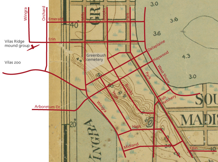
Q. What landscape feature on the east side of the isthmus caused Madison’s factory area to develop there?
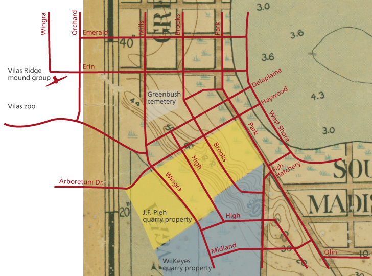
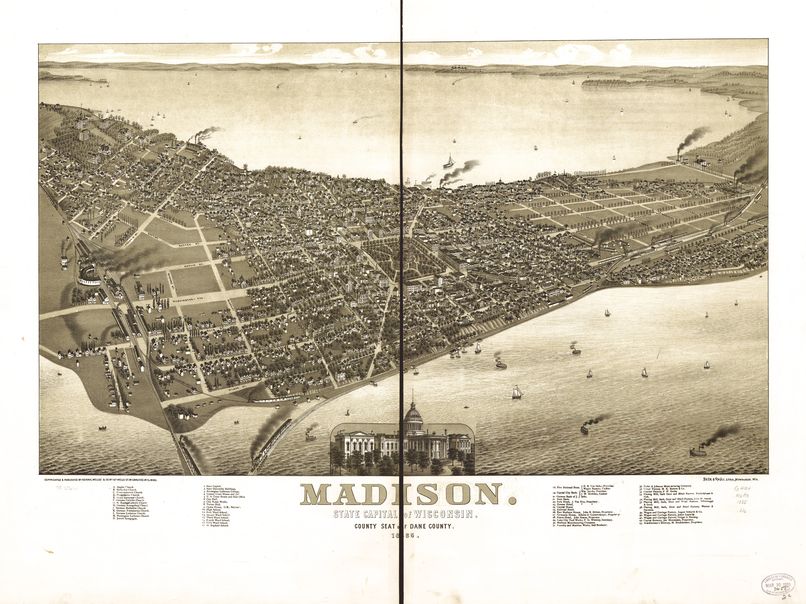
A. You could write a book to answer this question, and thankfully someone has. Businesses and railroad lines built up around a mill on the Yahara River, but a large part of the east side lay under the Great Central Marsh. See the tidy but empty grid of tree-lined streets bisected by East Washington Avenue? That 1867 panorama didn’t match reality. The marsh covered the area between East Washington and Williamson. Used for a dump, it polluted residential wells, burned in the dry season, and often stank. Once the marsh was filled, factories used the newly available space.

End-of-decade holiday blowout quiz

November 24, 2009

The year’s final quiz is open-book and open-Internet. If you’re not sure, give your best guess—who can pass up a chance at this prize? The winner gets either two lively hours in the field with Gordon and Jeff (hot chocolate provided), or Bob Birmingham’s Spirits of Earth, a book about Madison’s effigy mounds due out in December. Terrence the Unseen Madison cat breaks ties. Send answers via e-mail (jeff@unseenmadison.com or gordon@unseenmadison.com) or comment.

1. In 1855, the Yahara chain of lakes got a new set of names: Kegonsa, Waubesa, Monona, and Mendota replaced First, Second, Third, and Fourth lakes (numbered in the order they’d been surveyed). Where did the new names come from?

a. what the Ho-Chunk called the lakes

b. what the Sauk and Fox called the lakes

c. what the Ojibwe called the lakes

d. what Madison officials called them after consulting faulty vocabulary lists to find attractive Indian names

2. Which tree species dominated the Four Lakes area as noted in the 1834 public land survey?

3. How many trees older than the 1776 Declaration of Independence still stand in Madison?

a. only one (PDF)

b. about 50

c. about 150

d. about 250

4. What landscape feature on the east side of the isthmus caused Madison’s factory area to develop there?

5. How did the maple forest east of Lake Mendota (which gave Maple Bluff its name) survive in a savanna landscape that Native people burned regularly, since maple isn’t fire-resistant?

Visiting Nine Mounds in Verona with quiz winner

November 12, 2009

Recently our September quiz winner, Mirna Santana, collected her prize: spending a wet morning with Gordon and Jeff in Verona. Thanks to Mirna’s good company it was more fun than it sounds. Our modest mission was to find the reason for Nine Mound Road in Verona. We supposed there had been nine effigy mounds nearby, and it turns out that “Nine Mounds” stood on a hilltop near the Sugar River, a little west of today’s Nine Mound Road (click map to enlarge). The mounds were probably plowed under in the 1880s.

After our Dead Lake Ridge podcast we couldn’t help noticing the massive quarry operations along Nine Mound Rd. Unlike Dead Lake Ridge, here the quarries had nothing to do with the destruction of the mounds. The quarries mine sand and gravel from the outwash of the Johnstown moraine, the farthest reach of the last glacier. The moraine is easy to see at Prairie Moraine county park. Listen to audio from our trip:

Visit October quiz locations before winter

November 2, 2009

Unseen Madison is impressed: our October quiz winner knew all 7 locations for these Madison-area effigy mounds. Another person had 6 and two had 5. Pheasant Branch Conservancy and Spring Harbor were the most unfamiliar locations. You’ll see from the photo that Pheasant Branch is worth a special visit. Spring Harbor, just off University Ave., may be on your way. The great thing about our local effigy mounds is that most are easy to find. We encourage you to take one small detour a week to see mounds! Click the thumbnails for larger images and more information.

We’ll have a November quiz soon. Once again the stakes will be high! As always the winner receives two hours in the field with Gordon and Jeff, or something else we haven’t thought of yet (October’s alternative prize was Indian Mounds of Wisconsin by Bob Birmingham and Leslie Eisenberg).

Where exactly was Dead Lake Ridge?

October 22, 2009

See two stunning 1870 stereoscopic photos of Dead Lake Ridge, plus maps of today’s streets superimposed on 1901 Madison. Dead Lake Ridge was still a high and formidable feature in 1901, though quarrying was well underway.

Note the wetlands on both sides of the ridge — lakes Wingra and Monona did not have distinct shorelines. Park St., West Shore Drive, and N. Wingra Drive are built on fill.